304 Deer Field Road
(or Deerfield Drive on some GPS units)
Mount PleasantPA 15666
304 Deer Field Road
Mt. Pleasant, PA 15666
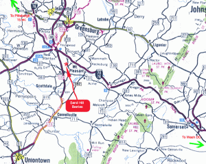
Come to Mt. Pleasant from the north or south by taking Rt. 119 or Rt. 819 or Rt. 981. From the east or west take Rt. 31 or Rt. 70 to Rt. 31E.
From the south of Pittsburgh, take Rt. 51S to Rt. 70E to Rt. 31E. From west and north of Monroeville, take the PA Turnpike to Exit 75 (New Stanton), then follow Rt. 119S to Rt. 31 E. Take Rt. 31E into Mt. Pleasant (Main St.).
A shorter route but no big signs: Take 119 South from Turnpike Exit 75. Get off at West Tech Drive exit. Bear right off exit ramp. Turn left at light. Turn left at the first opportunity (immediately after crossing over 119 on an overpass). Follow the road around the bend and up a hill (approximately 1 mile). When you come to the woods make a VERY ACUTE left. Follow this tar and chip road down over the hill, cross the railroad, and turn left onto our farm lane.
From the WWI doughboy statue on Main St. (Rt. 31) in the center of Mt. Pleasant, take Rt. 819N (same as N. Diamond St., then Low St.). Follow Rt. 819N for 2 miles; on the left you will see a large Sand Hill Berries sign directing you to turn left. Follow this township road to our farm lane, which is also marked with a sign. A few landmarks after you pass the doughboy: You will pass a Shop ‘n’ Save on the right. Just after this, 819N bends to the left. As Rt. 819N leaves Mt. Pleasant, you will come to the intersection of 819 and 981. You will stay on 819N; our sign is just 7/10 mi. past this crossroads.
GPS position: 40 10.46′ N 79 33.16′ W